

Text size:
Pico do Pedro - Pico da Esperança - Fajã do Ouvidor PR4SJO
How to get there
Leaving Velas village, by east, follow the Regional Road 1-2A for approximately 9 kilometres until you find the sign indicating “Nortes”, following that direction. Go about 9 kilometres until you find a dirt path to the right with the indication to Pico da Esperança. Follow this path around 6 metres, where you will find the beginning of the walking trail.
Recommended gear
Appropriate footwear for walking, waterproof jacket, hat, sunscreen and water.

Gallery
This linear route begins at the base of Pico do Pedro (hill), passes through Pico da Esperança, the highest part of the island with 1053 metres and ends at Fajã do Ouvidor, on the north coast.
The trail runs partly through the central volcanic ridge, between 800 metres and 1000 metres in altitude, and is partly within the Pico da Esperança e Planalto Central Protected Area for the Management of Habitats or Species and the geosites of the Central volcanic ridge and Fajã do Ouvidor and Ribeira da Areia. Along the trail, you can observe a great diversity of flora species, such as Hypericum foliosum, Vaccinium cylindraceum, Frangula azorica and Ilex azorica. Regarding fauna, you can see the birds Fringilla coelebs moreletti and Turdus merula azorensis. Before going down to Fajã do Ouvidor, visit the São Jorge Park House, where you can discover some more treasures of the Natural Park.
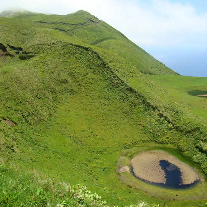
Start the trail at the base of Pico do Pedro, near the EN3 road, on a dirt path. Go around the mountain on the north side and follow the signs until you find the arrow with the detour to Pico da Esperança. Until then, the route goes around several other peaks, such as Carvão, which has a crater inside, Junça, Verde and Montoso and Morro Pelado, which has Algar do Montoso (volcanic pit), the deepest in the Azores, 140 meters deep. At the highest point of the island, you can go around the crater and contemplate the lagoon inside and the neighbouring islands, Graciosa and Terceira on the north side and Pico and Faial on the south side.
Continuing the trail, you can see the highest point of the island with about 1053 metres, the Pico da Esperança and the Cordilheira Vulcânica Central (central volcanic ridge). In this place you can take a detour and climb the peak, where you can see, on days of low cloudiness, its lagoons and the surrounding islands Graciosa and Terceira on the north side and Pico and Faial on the south side.
Return to the main road and continue the trail now in a descending stage through the central ridge of the island. Pass by Pico do Areiro and further ahead, by Pico Pinheiro, both with lakes inside their craters. A little further on, you will come across a crossroad with GGreat Route of São Jorge 02 (GR02 SJO), where it is possible to connect with Fajã dos Cubres.
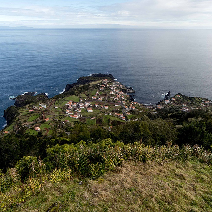
From this point, the walk goes towards North, to Fajã do Ouvidor, passing by wooden areas, agricultural roads and some sections in tarmac road. This fajã, unlike the other detrital fajãs typical on São Jorge, is from lava nature with large dimensions. This available flat area allowed further development with its local commerce, a fishing harbour and a bathing area, standing out the Poça de Simão Dias.