

Text size:
Great Route - Stage 3: Norte -Bananeiras
How to get there
Leaving from the centre of Vila do Porto, head towards the Quatro Canadas roundabout, getting out on the exit to Santa Bárbara parish, following the Regional Road to the centre of the parish. There go by the path of Barreiro to the housing centre of Lugar do Norte.
Recommended gear
Appropriate footwear for walking, waterproof jacket, hat, sunscreen and water.

The third stage of the Grand Route, with a length of 16,5 km, runs along the northeastern coast, where the island’s typical architecture predominates, with indigo blue stripes on the doors and windows.
This stage connects the Lugar do Norte to the Lugar das Bananeiras and allows you to visit one of the local priority geosites, going through the Pico Alto, considered by the scientific community as a biodiversity hotspot, where you can observe the entire island from its viewpoint. Finally, the route leads to the Lugar das Bananeiras, in São Pedro parish.
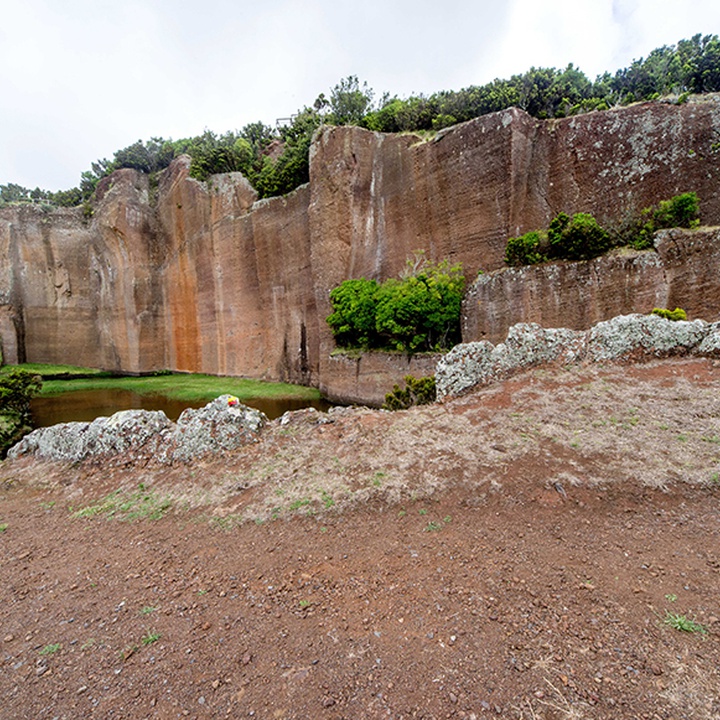
From the end of the last stage, in the centre of the Lugar do Norte, follow the marks towards the village of Santa Bárbara, passing by the places of Lagos, Poço Grande and Boavista. Continue through the interior of the place until you arrive at Poço da Pedreira, an old quarry also known as Pico Vermelho that used to supply cut stone for the construction of the typical houses of Santa Maria. Following the marks heading south, you will pass by the place of Arrebentão and enter the Lugar do Forno. Go down a pedestrian road until Ribeira do Salto, where you can have a glimpse of the waterfall of Cai’Água. The trail continues west until reaching Pico Alto, the highest point on the island at 587 metres, rich in endemic vegetation. This part of the trail crosses a forest area where you will pass by a connection to Baía de São Lourenço through PR06SMA – Areia Branca. After passing a geodesic landmark, take in the view of the village of São Pedro. From here, the road continues until the regional road, following among farming and forest fields, finishing at a fountain, near the road that leads to the Lugar das Bananeiras, where this stage ends.