

Text size:
Santo Espírito - Maia PR04SMA
How to get there
Leaving from the centre of Vila do Porto, take the Regional Road, towards the parish of Santo Espírito. Arriving at this parish search indication sings of the centre of the parish, where you will find the church. The trail begins near this church, as it is signed in the trail panel.
Recommended gear
Appropriate footwear for walking, waterproof jacket, hat, sunscreen and water
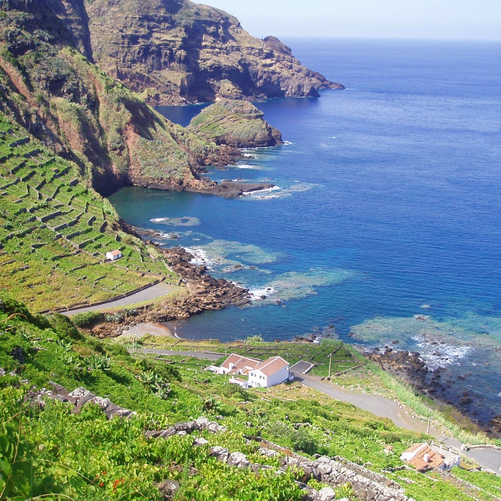

The trail begins at the centre of the Santo Espírito parish. It guides you through the local tradition of cultivating vineyards inside basaltic stone walls in terraced fields, and through the Cascata do Aveiro (waterfall), which, at about 80 metres high, is one of the highest in the country. The trail ends at the Ponta do Castelo, a site of old whaling activity and a priority site of geological interest.
Start the trail at the centre of the Santo Espírito parish, next to the church, and, following the signs, head west until you reach an old windmill. In this section of the trail, notice the large area dedicated to agriculture and livestock that gives meaning to the designation “rural parish”.
From the windmill, the trail proceeds to the southeast toward a scrubland of Sweet Pittosporum (Pittosporum undulatum), opening to a dirt and traditional cobblestone path, where you must turn right. In the pasture, there is an old fountain from which springs water. Toward the Lapa de Baixo, enter an area dominated by Japanese Cedar (Cryptomeria japonica). The signs will guide you to a detour that leads to an area of springs, then to the Ribeira do Aveiro (stream). The trail continues along the stream until you reach near the sea cliff, where the descent to the Maia begins through the terraced fields of vineyards and examples of the endemic Azorean Stonecrop (Aichryson santamariensis) and Azorean Pericallis (Pericallis Malvifolia). Along the descent, you can also stop at several points and contemplate the waterfall. Arriving at the Maia road, you can take a small detour to the left to view the Cascata da Ribeira do Aveiro from another perspective. The trail continues along the main road towards the Ponta do Castelo, passing by the bathing area, and at the beginning of the climb, you should turn left and follow a stone staircase that will culminate again at the Regional Road that goes down to the lighthouse. On the descent towards the sea, you can observe several species of endemic flora. Near the sea are traces of the whaling industry, which reached its peak between 1950 and 1957 in oil production, which ceased in 1966.