

Text size:
Baía de São Lourenço
Protected Landscape Area
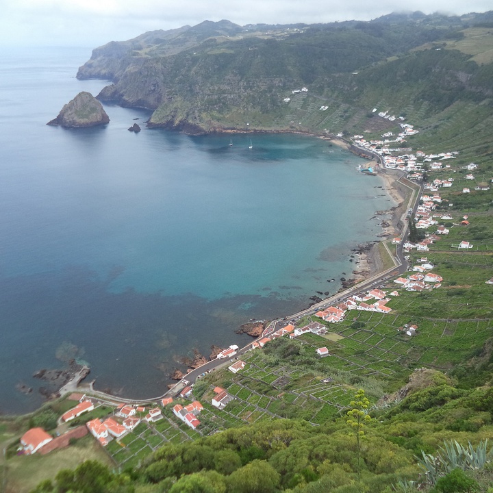

The Baía de São Lourenço protected area, covering around 60 hectares, is situated on the east coast of Santa Maria and stands out as one of the island’s most iconic cultural landscapes.
The bay forms a veritable natural amphitheatre, where vast terraced vineyards stretch across the entire hillside. These vineyards, traditionally planted with sweet grapes, are protected by ‘quartéis’, walls of basalt rock sourced from the hillside deposits, built to withstand the steep terrain. This agricultural system, which shapes the bay's visual identity, reflects the enormous human effort involved in cultivation: for decades, the grapes were carried on the shoulders, in wicker or palm-leaf baskets, to the production sites of the traditional Vinho de Cheiro and Vinho Doce.
At the south-eastern edge of the bay lies Ponta Negra, a site of great geological interest where submarine lava flows (pillow lava) outcrop and an important fossil deposit is found. With sedimentary deposits between 4 and 8 metres thick, this deposit is rich in ichnofossils (traces of marine organism activity) and in fossils of bivalves, gastropods, sea urchins and fragments of cetacean bones, which is why it is classified as a Class 3 fossil deposit within the Santa Maria Palaeopark.
Opposite Ponta Negra stands Ilhéu do Romeiro, whose erosion cave, adorned with stalactites and stalagmites, is accessible by boat. This islet is also home to the Azorean Bat (Nyctalus azoreum), the only terrestrial mammal endemic to the Archipelago, which is frequently spotted inside the cave.
The slopes of the bay and the adjacent islet offer excellent nesting conditions for various seabirds, notably the Cory’s Shearwater (Calonectris borealis) and the Common Tern (Sterna hirundo). The landscape thus combines natural and cultural values of great significance, making São Lourenço one of the most photogenic and characteristic spots on Santa Maria.
The bay can be explored via the Grande Rota de Santa Maria (GR01 SMA) and the Areia Branca walking trail (PR06 SMA), forming part of a geosite within the Azores UNESCO Global Geopark, where geology, biodiversity and human tradition come together in perfect harmony.