

Text size:
News
Regional Secretariat for the Environment and Climate Change upgrades Pico Mountain geodesic landmark
Oct. 4, 2023
The Regional Secretariat for the Environment and Climate Change recently completed the upgrading of the "Piquinho" geodesic landmark in the Pico Mountain Nature Reserve.
According to the Regional Secretary for the Environment and Climate Change, Alonso Miguel, the intervention to upgrade the "Piquinho" geodesic landmark, whose project was presented in March this year at a meeting of the Regional Council for the Environment and Sustainable Development, "intended to improve the safety conditions of the site, fostering landscape improvements at Portugal's highest point and improving the Pico Mountain Nature Reserve."
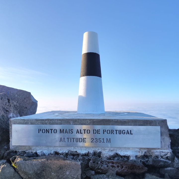
Alonso Miguel explained that Pico Mountain is a stratovolcano, rising 2351 metres above sea level, which supports alpine and subalpine 'habitats' that are home to various protected flora species.
This protected area, covering some 1,341 hectares, is part of the Pico Island Natural Park. It covers the Pico Mountain, Prainha and Caveiro Special Conservation Area, as part of the Natura 2000 Network, and is a priority Geosite of international importance within the Azores Geopark - UNESCO World Geopark.
"This is a unique natural heritage with recognised scenic, ecological and cultural value, being highly sought after by tourists. As such, it needs to be protected by regulating access and controlling visits so as to respect its load capacity. However, it also deserves to be improved, and therefore it was important to renovate the 'Piquinho' geodesic landmark, which was in an advanced state of disrepair while ensuring better safety conditions for visitors," he added.
The Regional Secretary emphasised that the upgrade consisted of a minimalist intervention, maintaining its primary function in terms of geodesy and cartography, which included the construction of a new geodesic marker as well as the base on which it stands.
In compliance with current geodesy rules, the new geodesic landmark now has a conical shape, more suited to the extreme weather conditions that often occur on the mountaintop, and some reference elements have been added, such as a compass rose at its base or elements describing or classifying the location.
Alonso Miguel noted that "the intervention represents the culmination of an extensive planning and coordination process on the part of the Regional Secretariat for the Environment and Climate Change, which relied on the helpful and indispensable collaboration of the Portuguese Air Force to transport the materials and equipment needed to carry out this work, which were deposited in the western area of the Crater and then transported by hand to the top of 'Piquinho'."
"This geodesic landmark had not been upgraded since 1995, given the difficulties of transporting materials and equipment to the site. Nevertheless, the operation was successfully carried out under favourable weather conditions due to the sense of mission, work ethic and exceptional physical and technical preparation of the vast team involved, made up of operational and technical staff from the Regional Secretariat, members of the Mountain Rescue Team and the Madalena Humanitarian Association of Volunteer Firefighters as well as members of the Azores Mountain Guides Association," he added.
The minister also emphasised that, in addition to all the logistics involved in planning and preparation, the intervention involved significant coordination of resources for the transport of materials and equipment. Teams were deployed in different locations, namely a team of six at the airport on Pico Island and a team of 25 on the mountain, who stayed overnight in the crater for two nights to carry out the project, with the collaboration of seven rescue team members and several mountain guides.
According to Alonso Miguel, "we were fortunate to count on the special participation of Squadron 752 'Fénix,' from Air Base No. 4 of the Portuguese Air Force, with the aid of the EH-101 Merlin aircraft, which made it possible to carry out the logistical operations to transport materials and equipment to the west of the Pico Mountain crater. The crew in charge showed a high level of competence and professionalism, considering the difficulties arising from the altitude and the specificities of the surrounding terrain."
The Regional Secretary emphasised that during this operation, it was also possible to transport various materials and electronic equipment to the observatory of the University of the Azores, a research station installed in the Crater of the Mountain, as well as to remove, on the way down, waste and obsolete material that had accumulated over decades in this station, in addition to ensuring the removal of all waste resulting from the intervention to upgrade the geodesic landmark.
Alonso Miguel, who was a member of the team working on the entire operation at the top of the mountain, was accompanied by the Regional Director for Spatial Planning and Water Resources, Emanuel Barcelos, who is responsible for the maintenance of the regional geodetic network. As he pointed out, this was a demanding and complex mission, whose successful completion has fulfilled an ambition of the XIII Regional Government of the Azores, which has further enhanced the Pico Mountain Nature Reserve, while also making an important contribution in terms of research, environmental monitoring and scientific development.
Subsequently, a team of eight people, coordinated by the Director of the Pico Environment and Climate Change Service, Vanda Serpa, went up to complete and paint the geodesic marker.